|
“In the midst of this war of words and tumult of opinions, I often
said to myself: What is to be done?”
(Joseph Smith - History 1:10)
The popularized Mesoamerican setting, and
opposing Heartland “Book of Mormon geography”
model are both scripturally unfit. Want proof? Ask a groupie from
either camp to cross on foot their proposed
“river Sidon”, east of where they allege the Book of
Mormon land of Zarahemla was.
Most importantly, ask them to please walk their
“line
Bountiful and the land Desolation”
-
the
distance described in the Book of Mormon that took only a day and a
half to cross.
(Alma 22:32) In short,
nicely
ask proponents to put their maps to the test by walking the walk. Say,
“do
it or Sheket!”
- that's Hebrew for “Silence”, “Be still”; - nicer than saying “Shut up!”.
What is meant by "journey"?
In
Israelite scripture, days journeyed means days
walked, not ridden or
rowed, or spirited away. See for example
Jonah 3:3-4, where
מַהֲלַךְ,
which means
“walk”, is translated
“journey”. See also Genesis 12:9 where “journeyed”
suggests
הָל֥וֹךְ,
walked. (Genesis 13:3)
The Hebrew word
דֶרֶךְ,
meaning
“tread, march”,
is also translated “journey”. This word likewise implies a distance traveled
on foot. See for example, Genesis 30:36,
Numbers 11:31.
The Oxford English Dictionary gives an early definition of
“journey” as “A day’s travel ... usually estimated in the Middle Ages at 20
miles.”
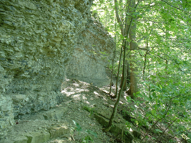
The type of leather hiking sandals that I wore when
I walked the line Bountiful. NO running
shoes allowed in this competition. The scripture says "...it was only
the distance of a day and a half's journey for a
Nephite, on the line Bountiful ..." So no sprinting relays with
athletes positioned at intervals along the proposed line. I also wore
leather sandals when
I crossed the river Sidon on the east of Zarahemla.
In scripture, a “day” journeying means
traveling on foot during
a
period of daylight.
(e.g.
Alma 56:40).
So no traveling at night - that would be cheating - besides your muscles are
going to be so sore at the end of the day that you will want to rest.
Spurious Central American Model
The
popularized Central American Model, drawing on
unsigned early Mormon newspaper articles,
which in fact entail
exaggerated hemispheric geography, has fans believing that the wide Isthmus of
Tehuantepec
is the
Book of Mormon’s “small neck of land”. Never
mind that the Book of Mormon “narrow pass” (presumably within the
“small neck”) had a sea (singular) “on the west and on the east”.
(Alma 50:34) The alleged Mesoamerican
Desolation – Bountiful line runs from the Gulf of Mexico north to the
Pacific Ocean south - about
125 miles. Never mind that scripture says the line
ran “from the east to the west sea”. You can, mull over Olmec and Mayan sites all you
like, but let’s see a groupie cross Tehuantepec (yellow)
in a day and a half - on foot! The most popular Mesoamerican settings place
the entire Desolation - Bountiful line within the “narrow neck of land”. The
actual Desolation - Bountiful borders were “by the narrow neck” - not within it.
(Alma 63:5)
In
Mesoamerican settings, either the Usamacinta or the Grijalva
are argued to be the river Sidon that lies east of Zarahemla. Cross that too
jaguar fan! (John L. Sorenson, An Ancient American
Setting for the Book of Mormon pg. 36.
Note: Weingarten’s Beit Mikra article which Sorenson cites
(footnote pg. 38) does not actually back up
Sorenson’s
skewed directions
argument. I have my doubts that Sorenson
actually read Weingarten’s “Beth Mikra” article - it’s in Modern
Hebrew. I found a copy at the U of U Marriott Library, and got feedback on it
from Hebrew professor Dr. Harris Lenowitz.
I'm calling out Brother Sorenson on this!)
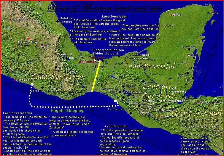
Exaggerated Heartland Model
Above is
a recent map of the competing Heartland Model. Hmmm! Why is the Land of Desolation missing from the map (it's not
labeled)? Desolation should be north of Bountiful
(Alma 22:31),
but with “Bountiful”
shown east of
“Zarahemla” and “Manti”
on the map (these lands should be south of Bountiful) who knows where
“Desolation” will finally end up in this setting. I have added the yellow
line and the question mark to call attention to what is missing.
I think someone is a little reluctant to place “Desolation” on
the map; because no matter where they place it, it’s asking for
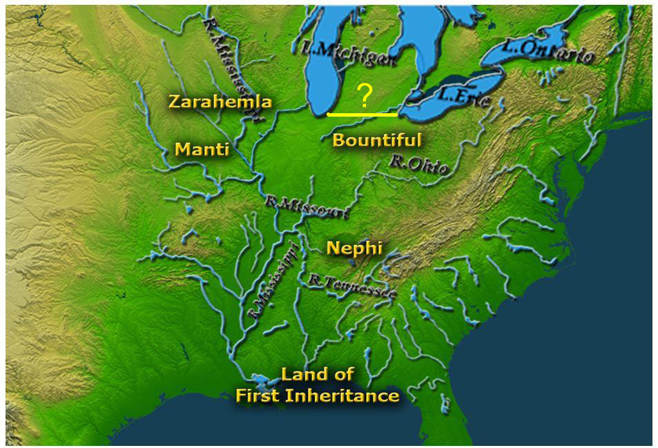
trouble. Take a look at an earlier version of the Heartland setting.
(See below - Wayne N. May, THIS LAND Only One
Cumorah! Volume II, pg. 50-51) The model clearly
has the
“Land of Desolation” in Michigan and Ontario.
Also note the incredibly wide, discontinuous “narrow pass” – wider
than the Niagara Isthmus.
Yet according to scripture “the narrow pass” entrance is so small,
it’s
described as a
“point”.
(Alma 52:9)
It’s also debatable whether the proposed pass has “the sea, on the west and on the
east.” (Alma 50:34) Moreover, if
the Niagara Isthmus is “the narrow neck of land, by the place
where the sea divides the land”
(Ether 10:20), then
“the west sea” where Hagoth launched his “exceedingly large
ship” has to be Lake Erie.
(Alma 63:5)
This means that “the land Bountiful” has to be in western NY (choice farm
country in Joseph Smith’s boyhood state) not the sprawling, skewed region
laid out in the Heartland Setting.
LDS scholar
Ed Goble
was the principal originator of the Heartland
Model. Intellectual honesty drove Ed to become a sharp critic of his own
work. In its formative period, Ed was the main man who put the model
together. A few others contributed key pieces here or there. Ed finally
abandoned the erroneous geography to another, who was determined to continue
promoting it to Latter-day Saints. Ed has remained true to the position that
at least Cumorah is correctly placed on the Heartland Setting map.
(LDS Doctrine and Covenants 128:20)
See Who Originated the Heartland Model?
Early Heartland Model
The
nascent Heartland model’s "Desolation - Bountiful line" is just under 200
miles.
Try
walking that in a day and a half! A revision of the Heartland model’s "Desolation - Bountiful line"
(that came out after the first publication of this article)
is also discussed in
Who Originated the Heartland Model?
If
Heartland setting proponents are going to place
“Manti” in Missouri
(based on Samuel Tyler’s Journal entry - 25 September, 1838) they should
certainly feel obliged to place “Desolation” in
Illinois, based on the Levi Hancock Journal.
(Autobiography of Levi Hancock (1803-1882),
copied from his journal by Clara E. H. Lloyd, great-grand daughter, pg. 27)
The trouble is, these speculative geographic views contradict.
The early Mormon journal entries are far from canonical, and definitely
cannot be relied on for placing Book of Mormon lands.
(See W. W. Phelps' LAND OF DESOLATION)
It’s
time more realized that ancient
Israelites coordinated directions
based on the perceived movements of the heavens: East
faces sunrise -
מִּזְרָח.
See for instance Joshua 11:3.
The Heartland and Central American models are not only exaggerated in key
places, the models are both so skewed in directions, that they fail
Israelite coordinates and common sense.
In the
Heartland Setting, the Iowa Mormon settlement with the
namesake “Zarahemla”, is presumed to reside in the Book of
Mormon land Zarahemla, even though scripture doesn't say this.
(LDS Doctrine and Covenant 125:3)
The passable river Sidon
(on the east of Zarahemla) is therefore alleged to be the Mighty Mississippi - gulp!
Here we
must insist on no swimming or snorkeling when crossing Old Man River. This part of the “Walk
the Walk” contest should require getting wet, but not completely soaked. In
the case of the Heartland Model, this would mean nothing short of walking on
water!
Heartland advocates argue that there could have been a sandbar that the
ancients crossed over on. Hmmm! Perhaps Heartland Model enthusiast will ask
for an exception; allowing their contestant to paddle across in a
canoe or on a raft; even though there is no scriptural justification for this.
(Alma 2:15,
26-27,
34-35;
6:7)
We should point out that the real river Sidon could be crossed on foot at more than one location
- not just east of Zarahemla. Sidon, of course, could be crossed near its “head”.
(Alma 43:22;
43:40)
This poses a problem for the Heartland Model which erroneously posits that the
river’s
“head” is a confluence
with another great river downstream.
The fact is, Joseph Smith never taught that the Iowa
Mormon settlement with the
namesake “Zarahemla” was located in the Book of Mormon land of
Zarahemla. This is why, after the Lord "let the name of Zarahemla be named
upon" the Iowa settlement
(March 1841),
John Taylor and Wilford Woodruff felt free to publish the highly speculative “Zarahemla”
at Quirigua idea
(October 1842) - a notion which they
apparently later abandoned in favor Orson Pratt’s far-flung South American Zarahemla - published in the footnotes of the
1879 LDS edition of the
Book of Mormon (see for instance Alma 22:31 footnote 2q).
This brings the topic and challenge around to South American setting
opportunists. They too need to do more than squawk, selling media and tours
to gullible Mormons. They too need to put their proposed river Sidon and Bountiful line
to the test. Do it!
As for the American Heartland -
Yes,
Helaman 1:18 says that “the land
of Zarahemla”
was in “the heart
of their [the Nephite's] lands”, but this doesn't mean in Iowa or
“the heartland" according to modern American
definition. Good grief pay attention! The land of Zarahemla was on the
coast of the Book of Mormon “west sea”.
(Alma 22:27-33)
This is no small problem for the Heartland Model.
Its clear that the Heartland Model is mostly laid out wrong. Even so, the
American Heartland is part of the
Book of Mormon’s authentic literary setting.
Part of what we now call the American Heartland, fits the Book of Mormon “south country”
or “south countries”.
(Mormon 6:15;
8:2)
South of where? South of Amherst Ohio where Joseph Smith
delivered the revelation contained in Doctrine and Covenants section 75. In other words, south of Lake Erie
- the "west sea".
(LDS Doctrine and Covenants 75:8,
17)
The Book of Mormon and Doctrine and Covenants “south countries” are one and the same.
The American Heartland is
definitely not where the
Book of Mormon lands of Nephi, Zarahemla, and
Bountiful
are. These important lands are inland a short distance from the coast of
“the west sea”. Sister Phyllis Olive, heeding scriptural details,
got it right:
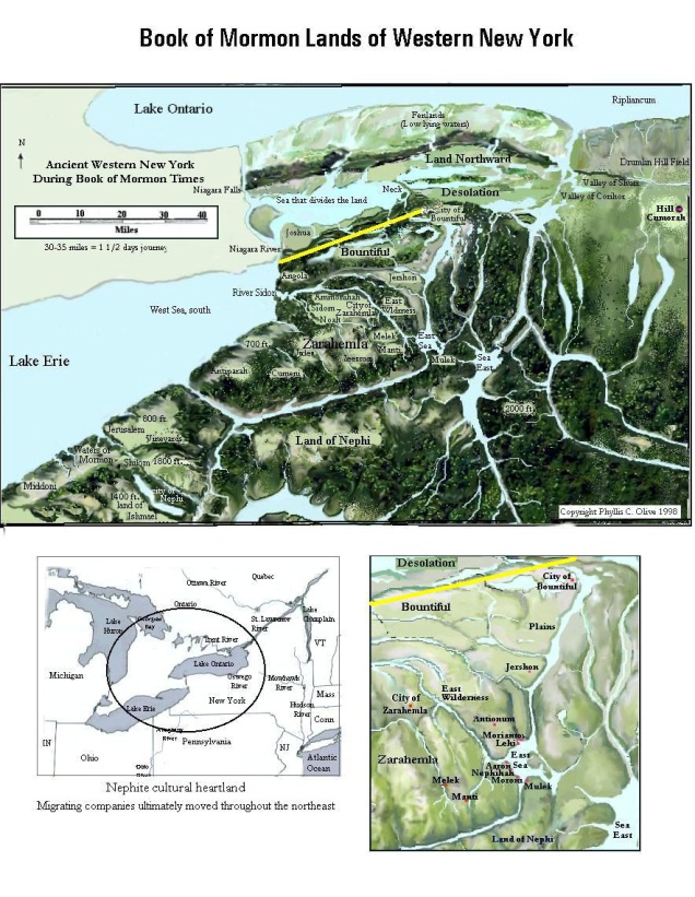
Textual Near Cumorah Setting
The
Desolation – Bountiful line, according
to Olive’s scripturally loyal Near Cumorah Setting, was a 35 to 40 mile span along
a Native American trail above the Onondaga Escarpment, western NY. The line
ran from the watery eastern borders of the land
Bountiful (near present day Batavia)
to “the west sea” (Lake Erie).
See
Why Lake Erie, and not Lake Tonawanda, is the Western Terminus of the Land Bountiful.
The eastern borders of Bountiful situated near the present day
Tonawanda Creek bend. In ancient times a chain of lakes stood in the
vicinity of the northward flowing creek. (Bulletin
of the Geological Society of America, Vol. 10, Tonawanda Valley, 32-34)
One of these long, finger-like lakes formed the eastern borders of
Bountiful. The belief
that
many North American rivers were once large inland seas or lakes
was discussed in
Joseph Smith’s
day.
(Josiah Priest, American Antiquities (1833
edition), pp. 360-367)
Even though Olive’s map labels the land of Desolation on the east of
“a small neck of land” (the Batavia Moraine),
Olive should be credited with proposing that Desolation is
“the land” (singular in
Ether 10:20) divided by
“the sea” (Lake Tonawanda, an extension of Lake Erie).
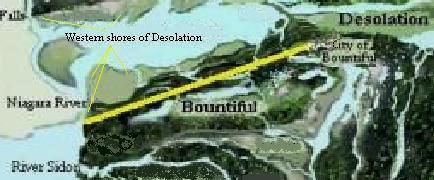
“...on the line Bountiful and
the land Desolation ...” -
“...the line which was between
the land Bountiful and the land Desolation”, running nearly parallel to the
Onondaga Escarpment.
(Alma 22:32-33,
3 Nephi 3:23)
Desolation’s
shores ran from the east all the way to Niagara, northward of the natural Onondaga Escarpment
line. The
Onondaga Escarpment was therefore literally
“between”
Desolation on the north and the elevated land
Bountiful on the south.
(3 Nephi 3:23) Thus, the shores of Desolation ran
parallel to, but at lower elevation than the inhabited land of Bountiful.
The wilderness of Bountiful is immediately southward and above the linear rise of the Onondaga
dividing line.
(Alma 22:31)
According to scripture the Nephites inhabited the land
Bountiful from
“the east unto the west sea” (Lake Erie).
Hence the description “the line Bountiful and the land Desolation”.
(Alma 22:32-33)
The linear
Onondaga Limestone Formation
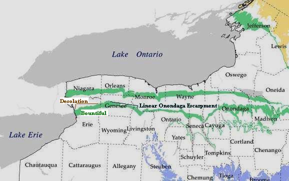
A more detailed depiction of the
Onondaga Limestone Formation and Escarpment
Desolation on the north, and Bountiful
“up” on the south of the linear escarpment.
(Alma 22:31)
Sidon river,
east of Zarahemla, fits northward flowing Buffalo Creek. The creek flows
northward and then turns westward out to “sea” as Buffalo River.
The
biblical
equivalent
of
Sidon
river is the brook Kishon - the northward flowing creek, that according to
the Bible swept away dead
enemies of Israel.
(Judges 5:21,
1 Kings 18:40, KJV)
Israel’s
northward flowing
“river Kishon”
Imagine
that. The Book of Mormon’s authentic core setting in the
general vicinity of the land Cumorah. We are talking about the one and only Cumorah
designated in LDS scripture; convenient to the boyhood country of Joseph
Smith.
(LDS Doctrine and Covenants 128:20)
Sadly,
many Mormons are so conditioned by unscriptural geographic portrayals that
they are dull to certain facts
- even when read aloud directly from scripture. Take for instance the fact
that a search party sent northward to find Zarahemla, arrived instead in the
vicinity of a land among many waters
(proximal to Cumorah). The search party thought they had found Zarahemla! Zarahemla
cannot possibly be thousands or even hundreds of miles from Cumorah! (Mosiah 8:7-8;
21:25-26,
Mormon 6:4)
Consider
also the fact that a fortified line between the land
of Zarahemla (on the south) and Bountiful (on the north) was only a day’s journey inland from
the “west sea” to the eastern borders.
(Helaman 4:5-7)
How
about the fact that the minimum possible distance between the environs of
the city of Lehi-Nephi and the land of Zarahemla
was only 12 – 8 = 4 days on foot - if you knew the way!
(Mosiah 23:2-3;
24:25)
Hello - it was little more than a night’s march northward from
the elevated “course of the land of Nephi”
down to Gideon which was east of the river Sidon
(east of Zarahemla).
(Alma 2:23-27;
50:7-8)
Note that traveling between Gideon and Zarahemla required crossing the river Sidon -
apparently on foot.
(Alma 2:34;
6:7)
It was about a day’s wearisome march from the southern
city of Mulek
“in the
land
of Nephi”
(Alma 53:6),
to
Bountiful
in northern Nephite territory.
(Alma 52:16-39)
These facts and others, show that the core setting of the Book of Mormon
is geographically very compact (comparable in size to the Bible’s
core setting), and must situate in the region of Cumorah.
Whence all the erroneous, exaggerated geographic notions?
Sadly, they come from not paying enough attention to, or accepting scriptural details.
In fact, the Lord once condemned the
“whole
Church”
for treating the Book of Mormon
“lightly”.
(LDS Doctrine and Covenant 84:54-59,
Enos 1:10)
What does the Book of Mormon actually say about the river
Sidon, and the Desolation - Bountiful Borders?
29
And also there were many Lamanites on the east by the seashore,
whither the Nephites had driven them.
And thus the Nephites were nearly surrounded by the Lamanites;
nevertheless the Nephites had taken possession of all the northern parts
of the land bordering on the wilderness, at the head of the river Sidon,
from the east to the west, round about on the wilderness side; on the
north, even until they came to the land which they called Bountiful.
30
And it bordered upon the land which they called Desolation, it being
so far northward that it came into the land which had been peopled and been
destroyed, of whose bones we have spoken, which was discovered by the people
of Zarahemla, it being the place of their first landing.
31
And they came from there up into the south wilderness.
Thus the land on the northward was called Desolation, and the land
on the southward was called Bountiful, it being the wilderness which is
filled with all manner of wild animals of every kind, a part of which had
come from the land northward for food.
32
And now, it was only the distance of a day and a half's journey for a
Nephite, on the line Bountiful and the land Desolation, from the east to
the west sea; and thus the land of Nephi and the land of Zarahemla were
nearly surrounded by water, there being a small neck of land between the
land northward and the land southward. (Alma 22:29 - 32)
Thus there was an eastern shore. This doesn’t have to mean
an Ocean coast.
It’s obvious from the KJV Bible, that Israelites called lakes, “seas”.
In fact, the “east sea” of the Old World Promised Land
is a lake.
(Ezekiel 47:18,
Joel 2:20)
The head
of the river Sidon
was near the east to west running boundary dividing Lamanite and Nephite
territories.
The
Nephite land Bountiful etc. was “up” (at higher elevation) relative to the
more northern land Desolation.
The line
Bountiful
was only a 1.5 day journey across – “from the east to the west sea”.
The west
sea bordered the land
of Bountiful on the
west.
The
small neck of land was between the land northward (Desolation) and the land southward
(Bountiful etc.). The small neck of land was therefore near the 1.5 day
Desolation - Bountiful line.
11
And thus he cut off all the strongholds of the Lamanites in the east
wilderness, yea, and also on the west, fortifying the line between
the Nephites and the Lamanites, between the land of Zarahemla and the land
of Nephi, from the west sea, running by the head of the river Sidon—the
Nephites possessing all the land northward, yea, even all the land which was
northward of the land Bountiful, according to their pleasure. (Alma
50:11)
27
…bordering even to the sea, on the east and on the west, and which
was divided from the land of Zarahemla by a narrow strip of wilderness,
which ran from the sea east even to the sea west, and round about on the
borders of the seashore, and the borders of the wilderness which was on the
north by the land of Zarahemla, through the borders of Manti, by the head
of the river Sidon, running from the east towards the west—and thus were
the Lamanites and the Nephites divided. (Alma
22:27)
Thus we
see that the west to east dividing line between the land of Zarahemla (on
the north) and the land of Nephi (to the south), ran from the west sea,
passed the head of the river Sidon (by the borders of Manti), to the east
wilderness which was near an eastern “sea” (body of water).
The
coast of the west sea was on the west of
Bountiful. The coast ran along the west of the
land
of Zarahemla, and along the west of
the
land of Nephi in the south.
25
Neither durst they march down against the city of Zarahemla; neither durst they cross the head of Sidon, over to the city of Nephihah. (Alma 56:25)
26
…the city of Nephihah,
…on the east borders by the seashore. (Alma 51:26)
7
…Alma …in the city of
Zarahemla, …went over upon the east of the river
Sidon, into the
valley
of Gideon… (Alma 6:7)
1
…Alma was journeying from
the land of Gideon
southward, away to the land of Manti, behold, to his astonishment, he met with
the sons of Mosiah journeying towards the land of Zarahemla.
(Alma 17:1)
6
…the Lamanites will cross the river Sidon
in the south wilderness, away up beyond the borders of the land of Manti.
And behold there shall ye meet them, on the east of the river
Sidon…. (Alma
16:6)
22
…in the wilderness, away by the head of the river
Sidon, that they might come into the
land of Manti... (Alma 43:22)
Thus we
see that the city of Zarahemla was “down” (at
lower elevation), and northward from a position near the dividing line
between the land Zarahemla and the
land
of Nephi. From this
position, the city of Nephihah (near the east
sea) was “over” on the eastern side of “the head of Sidon”.
The
head of the river
Sidon (northward from the land of Nephi, and southward from Zarahemla) was
“up” at higher elevation relative to Zarahemla. Sidon must therefore have flowed northward as
it ran down along the east of Zarahemla.
Was the Desolation - Bountiful line also bordered on the east by water?
22
And it came to pass that the voice of the people came, saying: Behold, we
will give up the land of Jershon, which is on the east by the sea, which
joins the land Bountiful, which is on the south of the land Bountiful;
and this land Jershon is the land which we will give unto our brethren for
an inheritance. (Alma 27:22)
26
And thus he went on, taking possession of many cities, the city of
Nephihah, and the city of Lehi,
and the city of Morianton, and the city of Omner,
and the city of Gid, and the city of Mulek, all of which were
on the east borders by the seashore.
27
And thus had the Lamanites obtained, by the cunning of Amalickiah, so many
cities, by their numberless hosts, all of which were strongly fortified
after the manner of the fortifications of Moroni; all of which
afforded strongholds for the Lamanites.
28
And it came to pass that they marched to the borders of the land
Bountiful, driving the Nephites before them and
slaying many.
29
But it came to pass that they were met by Teancum, who had slain Morianton
and had headed his people in his flight.
30
And it came to pass that he headed Amalickiah also, as he was marching
forth with his numerous army that he might take possession of the
land Bountiful,
and also the land northward.
31
But behold he met with a disappointment by being repulsed by Teancum and his
men, for they were great warriors; for every man of Teancum did exceed the
Lamanites in their strength and in their skill of war, insomuch that they
did gain advantage over the Lamanites.
32
And it came to pass that they did harass them, insomuch that they did slay
them even until it was dark.
And it came to pass that Teancum and his men did pitch their tents in the
borders of the land Bountiful; and Amalickiah did pitch his tents in the
borders on the beach by the seashore, and after this manner were they
driven. (Alma
51:26 - 32)
Thus we
see that the eastern borders of Bountiful
were near an eastern shore, and there was at least one body of water on the
east by the land Bountiful.
9
And he also sent orders unto him that he should fortify the land
Bountiful, and secure the narrow pass which led into
the land northward, lest the Lamanites should obtain that point
and should have power to harass them on every side. (Alma
52:9)
Thus we
see that the narrow pass was near the land Bountiful. The entrance to the narrow pass was
described as a “point” (not a line), but was proximal to the 1.5 day
Desolation – Bountiful
“line”.
Olive interprets "the narrow pass" and "the narrow neck"
as referring to the
same geographical feature.
5
And it came to pass that I did cause my people that they should gather
themselves together at the land Desolation, to a city which was in
the borders, by the narrow pass which led into the land southward.
(Mormon 3:5)
5
And it came to pass that Hagoth, he being an exceedingly curious man,
therefore he went forth and built him an exceedingly large ship, on the
borders of the land Bountiful, by the land Desolation, and
launched it forth into the west sea, by the narrow neck which led into
the land northward. (Alma
63:5)
Thus we
see that the
narrow neck and pass were by the Desolation - Bountiful
borders.
Scripture does not indicate that the Desolation - Bountiful borders
were within the narrow neck (as represented in the Mesoamerican Tehuantepec
Model).
34
And it came to pass that they did not head them until they had come to the
borders of the land Desolation; and there they did head them, by the
narrow pass which led by the sea into the land northward, yea, by the
sea, on the west and on the east. (Alma 50:34)
Thus we
see that the narrow pass near the Desolation - Bountiful line, passed
through the bed of an inland “sea”. This “sea” (singular) situated on
the west and on the east of the narrow pass. The narrow
pass was so small that a single sea was at once perceived "on the west and
on the east" of the entrance to the small land-bridge. The "small
neck of land" passed though, and above the inland body of water.
Conclusion:
The east
to west running Desolation - Bountiful line, extended from the east (likely from
an ancient shore, river or watery barrier) to the shore of the “west sea” (Lake Erie,
west and south of scriptural Cumorah). Notice that scripture does not say
the “line” started from the body of water called the “east sea”. Scripture
only says the “line” extended “from the east to the west sea”.
Evincing Olive’s model, there really and truly was an ancient “beach” or
“shore”
(Alma 51:32)
near the eastern borders of Batavia NY, in the general vicinity of Tonawanda
Creek. (Bulletin of the
Geological Society of America, Vol. 10, Tonawanda Valley, 32-34)
Students of
the
Book of Mormon should be careful not to presume that the
body of water on the east of Bountiful was the same as
“the east sea”. The
“the east sea” situated in southeastern
Nephite territory. In Olive’s
model, the Nephite’s
eastern seas were connected - not unlike Israel’s
eastern seas. There
is more than one “sea on the east” in the Old World Promised Land, (Joshua 12:3)
but only the more southern “salt sea”,
east of Jerusalem, is actually called “the east sea” in the Bible.
(Joel 2:20,
Ezekiel 47:18)
While It’s
true that the typesetter for the 1830 edition
of
the
Book of Mormon
capitalized
“East” (implying “East Sea”)
in the verse that reads
“...from the East to the West sea...” (pg. 288; compare Alma 22:32),
yet the Printer’s Manuscript has “east” and “west” in
lowercase:
The Printer’s Manuscript reads
“... from the east to the west Sea...”
Somewhere near the Desolation - Bountiful line was a small neck of land - a
pass or passage that passed through a
“sea” (ancient Lake Tonawanda), such that water was seen on the west
and on the east of the small isthmus (the Batavia Moraine).
Look at Sister Olive’s map of ancient
western NY, and remember scripture places Cumorah in the
Finger
Lakes
region of western NY.
(LDS Doctrine and Covenants 128:20)
In fact, scripture indicates that Cumorah was southward
from the large waters called
“Ripliancum”
(Ether 15:8-11 - Lake
Iroquois/Ontario
with its ancient fenlands),
and eastward from the Jaredite seat of power
near the land of Desolation and "the narrow pass".
(Ether 7:5-6;
9:3;
14:6-7,
11,
26,
Alma 22:30-32;
50:34;
52:9;
Mormon 3:5)
The head
of the river Sidon was near a narrow, east –
west strip of wilderness (likely the Cattaraugus River Corridor) that divided
the northern land of
Zarahemla
from the more elevated, southern
land
of Nephi - matching western NY.
Scripture
tells us that the head of the river Sidon was
“up” and southward, from the
land
of Zarahemla.
Unlike
the mighty southward rolling Mississippi, the
Book of Mormon river Sidon flowed northward, on the east of the land
of Zarahemla (just as
Buffalo
Creek does today, near East Aurora
NY). In the case of western NY,
“down” tends to be northward exactly as the Book
of Mormon describes.
These
covenant land features are all near scriptural Cumorah, not hundreds or
thousands of miles away!
Yes, there is archaeological evidence that
parallels the genuine literary settings of the Book of Mormon near
Cumorah. There really were Native American
earth and timber
fortified towns and citadels
in the region. There really were
mass human burials
in western NY - just as the Book of Mormon describes.
Mastodons and
metal objects really have been
removed from local NY sites. But such evidence doesn’t prove scripture to be
historical. What do you expect?

“...and there were elephants...”
(Ether 9:19)
In his renowned work An Approach to the Book of Mormon, Dr.
Hugh Nibley summarized the archaeological problem:
“...
Book of Mormon archaeologists have often been disappointed in the past
because they have consistently looked for the wrong things... In view of the
nature of their civilization one should not be puzzled if the Nephites left
no ruins at all. People underestimate the capacity of things to disappear,
and do not realize that the ancients almost never built of stone. Many a
great civilization which has left a notable mark in history and literature
has left behind not a single recognizable trace of itself. We must stop
looking for the wrong things.”
(The Collected Works of Hugh Nibley: Volume 6,
Appendix,
“The Archaeological Problem”,
pg. 431)
The
general literary setting of the Bible’s Promised Land is settled without
compelling archaeological proof. Biblical
archaeologists today, patiently dig for evidence to see if there really was, for
instance, a
King David in the 10th century BCE.
If they don’t find a lot of hard evidence right away, this doesn’t change their idea
of where the biblical Promised Land is located.
God’s
ancient covenant people do not need to wait for archaeological vindication
in order to identify their covenant lands by scripture.
(3 Nephi 29:1)
It’s
time for “Book of Mormon geography” squawkers to walk the walk!
Do it or sheket!
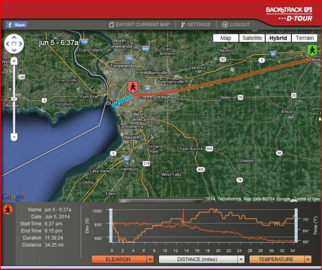
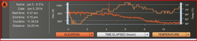
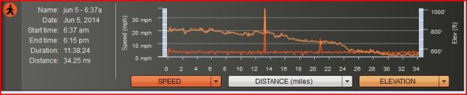
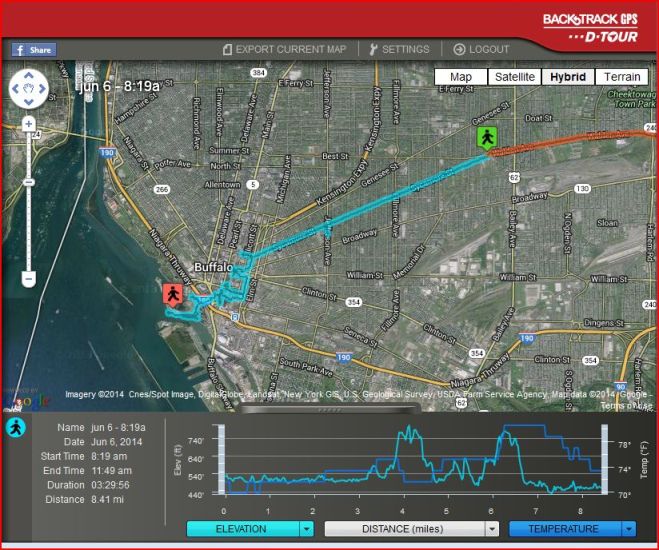
I did! I
actually put Phyllis Olive's Book of Mormon setting to the test:
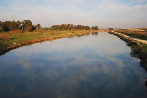
I crossed the river Sidon
(Buffalo Creek) east of Zarahemla (East Aurora, NY), and
I walked the line Bountiful along the Onondaga Escarpment in about a day
and a half - just as scripture describes.
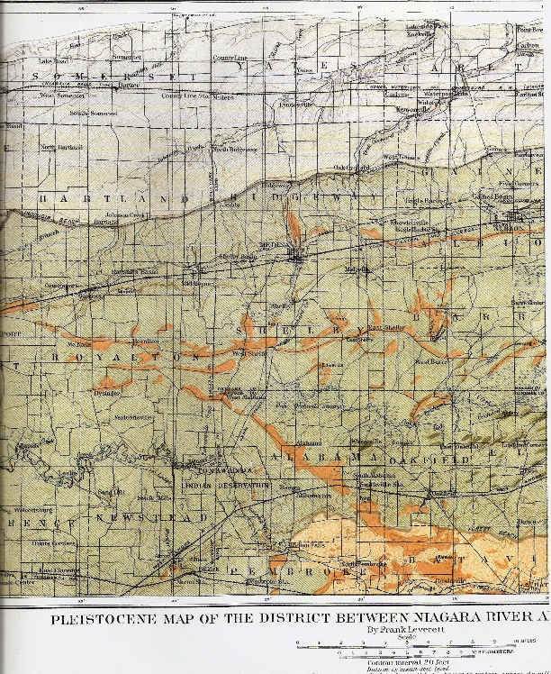
From Frank Leverett's Glacial Formations and Drainage Features of the Erie and Ohio
Basins
The Batavia Moraine (dark tan) passing diagonally through the bed of ancient
Lake Tonawanda (a land dividing arm of Lake Erie) now reduced to swamp lands
on the west and east of the narrow land-bridge or moraine. In the lower
right-hand corner of the geological map, Tonawanda Creek bends westward
before spilling over the Onondaga Escarpment at Indian Falls.
The westward bend is near the proposed start of the east to west running Bountiful line. The Bountiful line runs above, and
parallel to the escarpment. The escarpment is a natural dividing line
between hilly highlands to the south and lower northern flatlands
approaching the
shores of
Lake Ontario.
(3 Nephi 3:23)
|